772
FXUS65 KTWC 211955
AFDTWC
Area Forecast Discussion
National Weather Service Tucson AZ
1255 PM MST Tue Jul 21 2026
.SYNOPSIS...
The combination of ample moisture across Southeast Arizona and
an upper low moving across portions of the area from the east
will result in widespread showers and thunderstorms, especially
to the east and south of Tucson. These storms will be capable of
producing heavy rainfall. A Flash Flood Watch remains in effect
for Graham, Greenlee, Cochise and Santa Cruz counties through
10 PM MST this evening. Otherwise, daytime temperatures will
remain below average by several degrees into midweek increasing
to above normal late this week into this weekend.
&&
.DISCUSSION...
Abundant moisture remains in place with areas in Graham,
Greenlee, Cochise, and Santa Cruz saturated and seeing above
average stream/wash/river flows. These areas will be the main
focus with the Flash Flood watch remaining in effect through
late evening.
Current thinking remains the same as development and expansion
of convection around the periphery of the upper low continues.
With already susceptible conditions, it will not take much to
get flash flooding. We have already issued one FFW, where nearly
2" fell in less than 1hr. We are seeing similar rates from
additional development across SEAZ. HREF once again paints a
large area of 10% probs of greater than 3" in much of the watch
area. The entire watch has a risk, but there is one area of more
concern this afternoon into the evening. WoFS runs are consistently
highlighting QPF MAX values nearing 4" in localized spots, with
reasonable worst case (90th) percentile showing 2-3" from
western Cochise, eastern Santa Cruz into extreme eastern
Pima/Catalina and Rincon Mtns as well as extreme eastern Pinal
and western Graham.
As for the Tucson Metro, similar flavor as yesterday. High
likelihood of convection south and east of Tucson, including
the Santa Catalina/Rincon Mtns. The best chance for storms in
the metro will be the Catalina Foothills, Tanque Verde/east
side, and north into Catalina/Oracle. Anything that makes it
into the city center should be more of moderate to locally heavy
rain with embedded storms situation. Nonetheless, with abundant
moisture and above average soil moisture, we cannot rule out an
isolated instance of flash flooding. Latest WoFS runs continue
to support this scenario, but does provide a little more
confidence of storms migrating off the higher terrain into the
immediate communities from the Catalinas/Rincons. Given the
rates seen and the WoFS output, a localized flash flood threat
remains possible for these areas.
Upper level low meanders NW of the area by Wednesday with a
downward trend in convection. There still should be enough
moisture/instability that we could see some isolated to perhaps
scattered storms, but confidence is low on the area.
Despite the fact that we will still have daily afternoon and
evening showers and thunderstorms the second half of the work
week, there will be a distinct downturn in activity. The upper-
high center will move from Oklahoma today to southern New Mexico
24/00Z Thursday afternoon then up to the Four Corner by 26/00Z
Saturday afternoon. The approaching upper-high will increase
afternoon temperatures once again to around 5 to 8 degrees above
normal. The combination of drier air and modest mid-level flow
will increase the potential for showers and thunderstorms next
weekend to be more of the severe variety. In other words, the
Monsoon rolls-on.
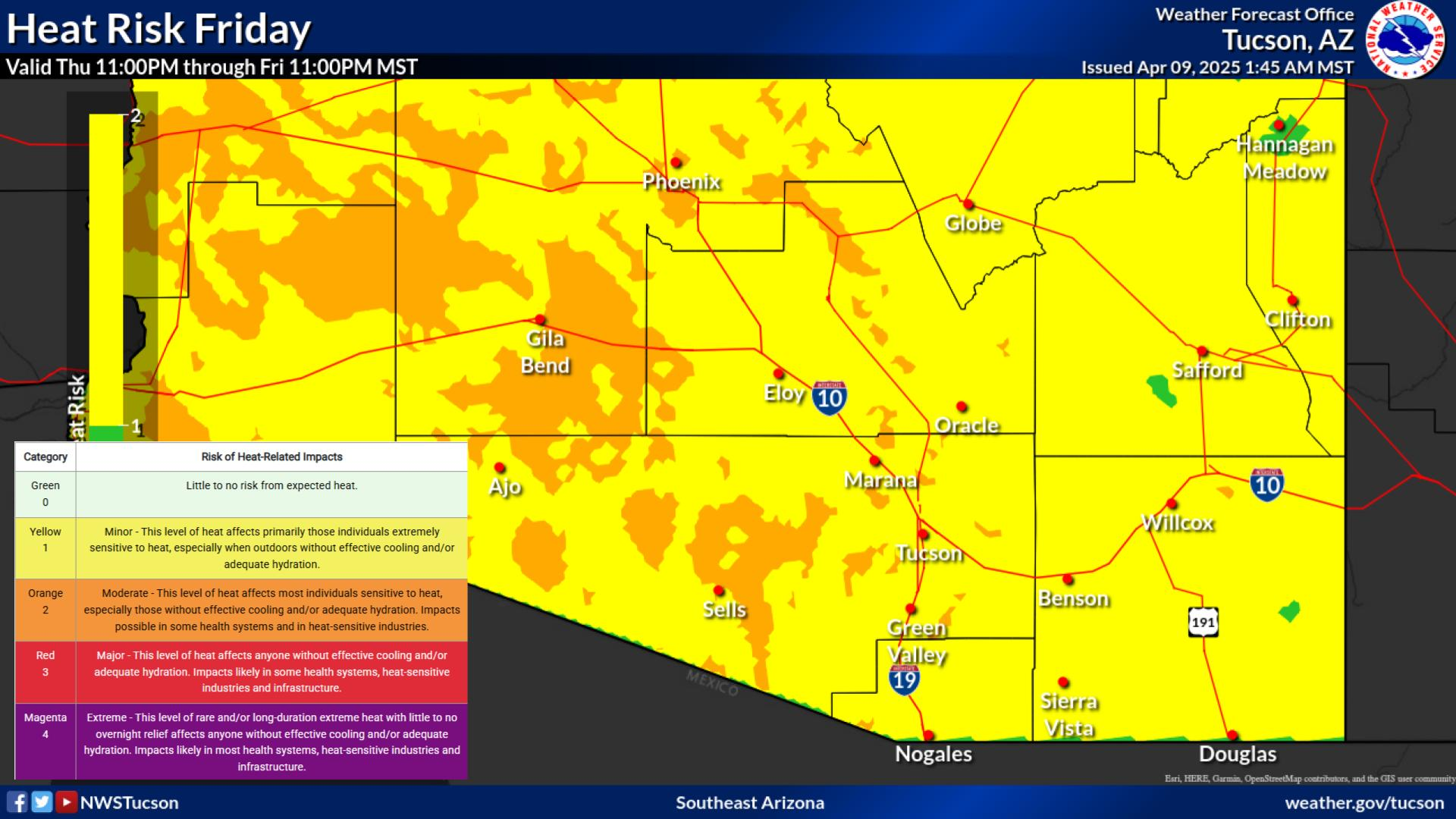
Daytime temps below average early this week, transitioning to
above average by midweek. Spotty major heat risk is possible for
portions of Pima County, generally around the metro and across
the western third of the county. In addition, the upper Gila
River Valley has some spotty major heat risk. As of now,
confidence is not high enough for an Extreme Heat Watch, due to
the limited coverage and possibility of monsoon activity/clouds
lowering aftn temps. We will monitor for now and message an
overall upward trend in temps and heat risk by mid week.
&&
.AVIATION /19Z TUESDAY THROUGH 19Z WEDNESDAY/...Valid through
22/18Z. SCT-BKN 6-8k ft AGL with FEW down to 4k ft AGL around
KOLS. SHRA/TSRA, some +TSRA developing and expanding in
coverage this afternoon. VFR, with the exception of brief MVFR
due to +TSRA/SHRA. Best chance is for KDUG/KOLS seeing these
impacts. VCHS/VCTS for KTUS, as activity should stay mainly
south and east. Sfc winds generally less than 12kts, except for
around storms where VRB gusts to 35kts will be possible.
Aviation discussion not updated for TAF amendments.
&&
.FIRE WEATHER...
Daily chances for thunderstorms will continue each afternoon
and evening through the next 7 days with day to day variability.
Widespread showers and thunderstorms are expected east and
south of Tucson again today. These storms will be capable of
producing heavy rainfall with the potential for flash flooding.
A Flash Flood Watch remains in effect until 10 PM MST this
evening for the eastern portions of Southeast Arizona. Min RHs
25-30% in the lower desert locations and above 40% in the
mountains through mid-week. By Thursday into the weekend, RH
could dip into the 17-22% range for the lower deserts west of
Tucson and the upper Gila River Valley as temperatures warm to
above average. Winds this week will remain mainly light and
under 15 mph, though strong and erratic winds will be possible
with any thunderstorm.
&&
.TWC WATCHES/WARNINGS/ADVISORIES...
Flood Watch until 10 PM MST this evening for AZZ503-507>513.
&&
$$
Visit us on Facebook, X, YouTube, and at weather.gov/Tucson
NWS Tucson (TWC) Office